In Hampden County, COVID-19 exacerbates a stark employment divide between urban and rural areas
Hampden County, Massachusetts, home of Western New England’s largest city, Springfield, has more COVID-19 deaths per capita than any other Massachusetts county as of May 20. This tragic fact is driven by the 74 lives lost at the Holyoke Soldiers’ Home, a nation-leading figure for a single long-term care facility.
But while death rates are often hard to calculate in real time, researchers at Applied Geographic Solutions, Inc. in Thousand Oaks, California have started to estimate the virus’s impact on a key economic indicator: unemployment rates. And for Hampden County, the results are devastating. Multiple neighborhoods in and around downtown Springfield have estimated unemployment rates over 35%. Just 2 miles downstream on the Connecticut River, zip code 01106, in suburban Longmeadow, has the lowest unemployment rate in the county projected for May 9 at 22.2%.
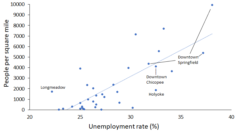
The modeled disparity in unemployment rates between downtown Springfield and nearby Longmeadow is illustrative of a county-wide trend: COVID-19’s economic impacts have been felt deeper in urban areas (see Figure 1). Holyoke and Chicopee are also hotspots for high unemployment rate estimates in the county, with their riverside downtown zip codes each cresting 32% unemployment as of May 9. Besides Longmeadow, the county’s communities with the lowest unemployment rates are mostly rural towns that hug the Connecticut state border, like Granville and Wales.
Figure 1: Correlation between population density and unemployment rate by zip code in Hampden County on May 9

Sources: Applied Geographic Solutions Inc., UnitedStatesZipCodes.org
Yet, the urban-rural divide in unemployment in Hampden County is not directly a result of the COVID-19 pandemic. On March 7, when there were only 13 confirmed cases in all of Massachusetts, zip codes near downtown Springfield and at an air force base in Chicopee were the only ones in the county with an estimated unemployment rate over 5%. While COVID-19 has not solely impacted workers in Hampden County’s urban areas, it has made the existing inequalities all the more eye-popping.

The data used in this tracker and research was provided by Applied Geographic Solutions, Inc. (AGS), of Thousand Oaks, California, according to their weekly release including estimates through May 9, 2020, and is presented with their written authorization. The methodology that AGS used to model this data is described here. Because the federal government does not report unemployment rates by ZIP Code or community, and issues unemployment reports on a time-delayed basis, AGS has created an economic model to estimate real-time unemployment by state and municipality using a combination of federal employment sources. In its modeling, AGS uses data from the Bureau of Labor Statistics labor force by ZIP Code and occupation; weekly state-by-state initial jobless claims by occupation; and monthly labor force publications that provide detailed unemployment estimates by state, and major metropolitan areas. AGS says this about its methodology: “On a weekly basis for the next several months, AGS will be creating and making available an updated, rolling weekly unemployment estimate at the block group, ZIP code, and county levels of geography. While we do not pretend to have “on the ground” information to support these estimates, our initial tests on the data to date suggest that our methodology is a reasonable one – we are focusing on the distribution of employment by occupation and using a series of estimates of vulnerability curves to simulate what is being reported at a national and state level.”
Andrew Mikula is the Lovett & Ruth Peters Economic Opportunity Fellow at the Pioneer Institute. Research areas of particular interest to Mr. Mikula include urban issues, affordability, and regulatory structures. Mr. Mikula was previously a Roger Perry Government Transparency Intern at the Institute and studied economics at Bates College.


